
Climatological distributions of δ13C of dissolved inorganic carbon in the Global Oceans
The climatology provides mapped data of δ13C in the preindustrial and the modern global ocean, as well as of the full 13C Suess effect over the industrial period. The distributions were constructed as described in Eide et al. [2017a] and Eide et al. [2017b]. The data are openly available but these two papers have to be cited whenever and wherever these data are used:
Eide, M., A. Olsen, U. Ninnemann, and T. Eldevik (2017a), A Global Estimate of the Full Oceanic 13C Suess Effect Since the Preindustrial, Global Biogeochem Cycles, 31(3), 492-514, doi:10.1002/2016GB005472.
Eide, M., A. Olsen, U. Ninnemann, and T. Johannessen (2017b), A Global Ocean Climatology of Preindustrial and Modern Ocean δ13C, Global Biogeochem. Cycles, 31(3), 515-534, doi:10.1002/2016GB005473.
The climatology was developed using data that was collected mostly during the 1990s, and the modern ocean δ13C and the full 13C Suess effect estimates should be considered to represent this time period.
The data are provided as two files, both on a 1˚×1˚ grid. One provides all data for the global ocean at 24 depth levels, starting from 200 m. The other provides a full depth grid of the 13C Suess effect, on 33 depth levels. Estimates for the upper 200 m preindustrial and modern oceans δ13C distributions could not be generated as there are insufficient data to describe the upper ocean δ13C seasonal cycle globally; see Eide et al. [2017a] and Eide et al. [2017b] for further details.
The climatology can be downloaded here.
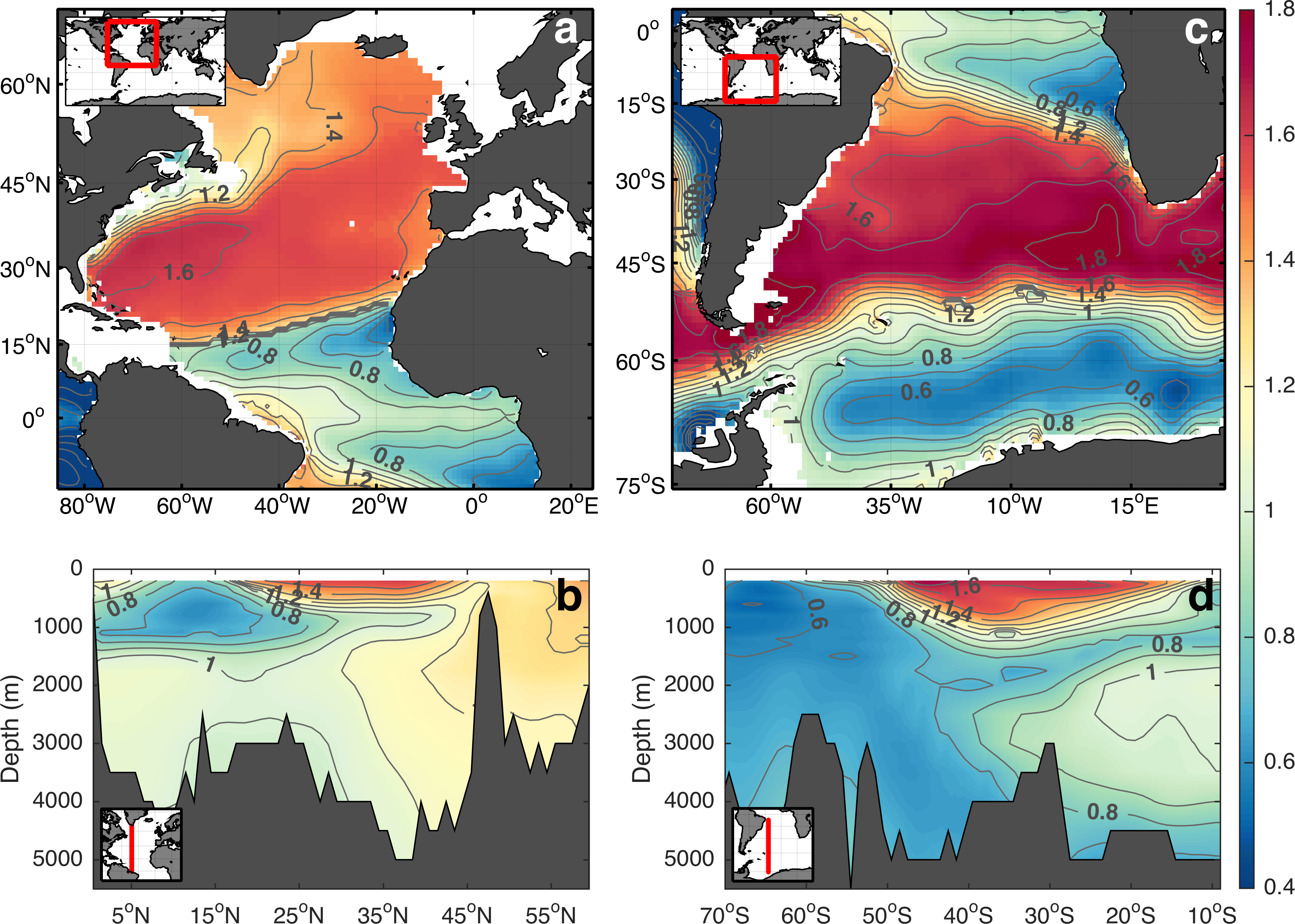
The preindustrial δ13C distribution (‰) at selected locations in the Atlantic Ocean; (a) at 200 m depth in the North Atlantic, (b) along 45˚W in the North Atlantic, (c) at 200 m depth in the South Atlantic, and (d) along 30˚W in the South Atlantic.
Paleogeological data syntheses
A database of dates relating to the build-up and retreat of ice over northwest Europe is being assembled by scientists at Department of Earth Science, University of Bergen and BCCR. DATED (http://www.uib.no/en/project/dated) aims to produce synchronous ice margin reconstructions, or time-slice maps, depicting the evolution of the Eurasian Ice Complex (including the Scandinavian, British-Irish, Barents-Kara-Sea and Svalbard Ice Sheets) through the last glacial cycle. The maps summarise the available geological evidence and therefore are a critical empirical test for results from numerical and isostatic ice sheet modelling. The first version of the database and maps, DATED-1, is now available here.
Chemical oceanography data syntheses
Scientists from the BCCR are heavily involved in the creation of the world largest data products in the field of chemical oceanography - those are international efforst under the umbrella of the International Ocean Carbon Coordination Project. GLODAP and CARINA provide carbon, nutrients and carbon data from the ocean interior. SOCAT provides carbon dioxide data from the global surface oceans. Please follow the links bewlo for detailed information.
GLODAP - Global Ocean Data Analysis Project
CARINA - Carbon Dioxide in the Atlantic Ocean
SOCAT - Surface Ocean Carbon Dioxide Atlas